
India is a big country in South Asia. India’s boundary covers 28 states and 8 union territories. Each state and union territory has its own capital city. The capital city of India is New Delhi, which is in the National Capital Territory of Delhi. It’s where the government works and where important decisions are made. In 2019, two new union territories, J&K and Ladakh, were created from the state of Jammu and Kashmir. This was the first time a state was divided into two union territories. From January 26, 2020, India will have 8 union territories and 28 states.
28 States and Capitals of India
Since January 26th, Daman and Diu merged with Dadra and Nagar Haveli to become one union territory. This happened through a law passed in Parliament, which reduced the number of union territories to eight. Some states in India, like Himachal Pradesh, Maharashtra, and Uttarakhand, have different capital cities for their summer and winter sessions of the legislative assembly. Similarly, Ladakh has two administrative capitals, Leh and Kargil.
It’s important to know the list of Indian states and their capitals for general knowledge. In 2023, India has a total of 36 entities, including 28 states and 8 union territories. Each state and union territory has its own administrative, judicial, and legislative centers. Some sources say that all three functions are carried out in the same capital city. Each state is led by a Chief Minister.
List of All 28 States and Capitals of India
Over the years, the number of states and union territories in India has changed. In 1956, there were 14 states and 6 union territories, but by 2014, these numbers increased to 29 states and 7 union territories. As from year 2021, India has 28 states and 8 union territories.
India is a country that follows a federal system, which means it is made up of different states and union territories. These states and union territories are further divided into smaller areas called districts. Each Indian state and union territory has its own unique symbols that represent its identity.
| Region | State / Union Territory | Capital |
| North East India | Assam | Dispur |
| Meghalaya | Shillong | |
| Arunachal Pradesh | Itanagar | |
| Nagaland | Kohima | |
| Manipur | Imphal | |
| Mizoram | Aizawl | |
| Tripura | Agartala | |
| South India | Karnataka | Bangalore |
| Tamil Nadu | Chennai | |
| Andhra Pradesh | Amaravati | |
| Telangana | Hyderabad | |
| Kerala | Trivandrum | |
| Goa | Panaji | |
| North, Central, East & West | Maharashtra | Mumbai |
| and Western India | Gujarat | Gandhinagar |
| Rajasthan | Jaipur | |
| Haryana | Chandigarh | |
| Punjab | Chandigarh | |
| Uttarakhand | Dehradun | |
| Uttar Pradesh | Lucknow | |
| Madhya Pradesh | Bhopal | |
| Chhattisgarh | Raipur | |
| Jharkhand | Ranchi | |
| Bihar | Patna | |
| West Bengal | Kolkata | |
| Odisha | Bhubaneshwar | |
| Sikkim | Gangtok | |
| Himachal Pradesh | Shimla |
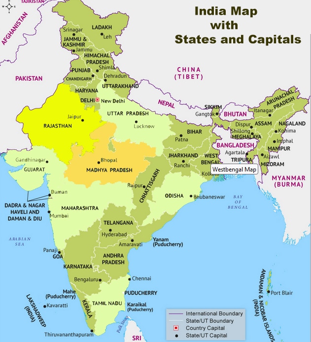
India Map with States and Capitals
8 Union Territories of India
The Union Territories of India are a unique administrative division that directly vests ruling power in the hands of the Union government. As of today, there are 8 Union Territories in India, each with its own distinct characteristics and significance. These Union Territories play a crucial role in the governance and administration of the country.
Here is a table listing the 8 Union Territories of India along with their respective capitals:
| Union Territory | Capital |
| Andaman and Nicobar Islands | Port Blair |
| Chandigarh | Chandigarh |
| Dadra and Nagar Haveli and Daman and Diu | Daman |
| Lakshadweep | Kavaratti |
| Delhi | New Delhi |
| Puducherry | Pondicherry |
| Jammu and Kashmir | Srinagar (summer capital)
Jammu (winter capital) |
| Ladak | Leh (summer capital)
Kargil (winter capital) |
Names of Union Territories of India
1. Andaman and Nicobar Islands:
Capital: Port Blair
Notable Features: Andaman and Nicobar Islands are known for their beautiful beaches, turquoise blue waters, and a blend of history. The archipelago comprises 572 islands, of which only 37 are inhabited. The islands have a rich history, with the British using them to detain Indian freedom fighters. The local tribes of Jarwa and Great Andamanese have maintained an aloof existence. The islands offer stunning beaches like Havelock and Neil Islands, inviting tourists to enjoy a peaceful and laid-back holiday. Scuba diving is a popular activity here.
2. Chandigarh:
Capital: Chandigarh
Notable Features: Chandigarh is a unique Union Territory as it serves as the capital of two Indian states: Punjab and Haryana. It is also a separate Union Territory itself, making it a distinct administrative entity. Designed by renowned architect Le Corbusier, Chandigarh is known for its urban planning and modern architecture.
3. Dadra and Nagar Haveli and Daman and Diu:
Capital: Daman
Notable Features: Dadra and Nagar Haveli and Daman and Diu are two former Portuguese territories that have been merged into a single Union Territory. They are known for their beautiful beaches, Portuguese forts, churches, and a mix of cultural influences.
4. Delhi:
Capital: New Delhi
Notable Features: Delhi is the capital of India and also a Union Territory. It is a historical and cultural hub, known for its monuments, heritage sites, and diverse population.
5. Jammu and Kashmir:
Capital:
- Srinagar (summer capital)
- Jammu (winter capital)
Notable Features: Jammu and Kashmir, formerly a state, was reorganized into two separate Union Territories: Jammu & Kashmir and Ladakh, as of October 31, 2019. This reorganization marked a significant change in the administrative structure of the region.
6. Ladakh:
Capital: Not explicitly mentioned (Administration may be shared between different locations)
Notable Features: Ladakh, created along with the reorganization of Jammu and Kashmir, is known for its breathtaking landscapes, high mountains, and distinct culture.
7. Lakshadweep:
Capital: Kavaratti
Notable Features: Lakshadweep is an archipelago of islands located in the Arabian Sea. It is known for its pristine beaches and clear blue waters, making it a popular destination for tourists.
8. Puducherry:
Capital: Puducherry
Notable Features: Puducherry, also known as Pondicherry, has a unique blend of Indian and French culture due to its colonial history. It is famous for its colonial architecture, beaches, and spiritual centers.
Union Territories of India on Political Map

Related Article : List of Major Indian Cities on River Banks
FAQs – States and Capitals of India and 8 Union Territories
Q1: How many union territories are there in India and what are their names?
A: There are 8 union territories in India. Their names are:
- Andaman and Nicobar Islands
- Chandigarh
- Dadra and Nagar Haveli and Daman and Diu
- Lakshadweep
- Delhi
- Puducherry
- Ladakh
- Jammu and Kashmir
Q2: Can you list the states of India that share a common capital?
A: The states of Punjab and Haryana share a common capital, which is Chandigarh.
Q3: As of today, how many states are there in India?
A: As of today, there are 28 states in India.
Q4: How many states and union territories are currently present in our country?
A: Currently, there are 28 states and 8 union territories in India.
Q5: Who holds the position of the head in the Union Territories of India?
A: The head of a Union Territory in India is called the Lieutenant Governor (LG). The LG is appointed by the President of India.
Q6: Which state was recently divided to form a new union territory?
A: The state of Jammu and Kashmir was recently divided to form two union territories: Jammu and Kashmir, and Ladakh.
Q7: Which Union Territory is considered the smallest in terms of area in India?
A: The Union Territory of Lakshadweep is considered the smallest in terms of area in India.
Q8: Which state is largest in terms of area in India?
A: The state of Rajasthan is largest in terms of area in India.
Q9: Among the states of India, which one is considered the smallest in terms of area?
A: Among the states of India, Goa is considered the smallest in terms of area.